The greater Odienné Project lies in the northwest Denguélé Region of Côte d’Ivoire, approximately 600 kilometres northwest of the commercial capital, Abidjan, and approximately 400 kilometres northwest of the capital, Yamoussoukro.
The project covers approximately 2,346 square kilometres in 7 permits – the granted Odienné East, Odienné West, Sienso, Sama, and Seydou permits and 2 permits under application (Figure 1 and Figure 2, Table 1).
Awalé is confident that the geological setting of the Odienné district is comparable to that of other significant Iron Oxide Copper Gold (IOCG) provinces globally. IOCG deposits are significant contributors to global copper and gold inventories, and the Company considers the Odienné Project to contain significant potential for the discovery of the first major IOCG deposit in West Africa.
In Q4 2025, Awalé launched a program of up to 100,000 metres of resource definition and discovery drilling, through 2026, at the Odienné Project. This large-scale program is planned to position Awalé to deliver a first Mineral Resource Estimate and Preliminary Economic Assessment for the Project in Q2 2026 and to advance toward a Pre-Feasibility Study in 2027 encompassing the BBM, Charger, and Empire zones.
Introduction
The greater Odienné Project lies in the northwest Denguélé Region of Côte d’Ivoire, approximately 600 kilometres northwest of the commercial capital, Abidjan, and approximately 400 kilometres northwest of the capital, Yamoussoukro.
The project covers approximately 2,346 square kilometres in 7 permits – the granted Odienné East, Odienné West, Sienso, Sama, and Seydou permits and 2 permits under application (Figure 1 and Figure 2, Table 1).
Previous Exploration
The Odienné project area was subject to previous first-pass exploration geochemistry in the mid-1990s through a joint venture between SODEMI and Randgold Resources. They completed shallow, broad-spaced soil sampling for gold and base metals over the greater portion of the project area and followed up with pitting and trenching. Significant anomalism was recognised across the sampled area which covered some 300 km2.
After that, infill geochemical sampling and mapping was completed over multiple targets. Despite returning significant gold and base metal anomalies, no follow-up drilling was completed.
In late 2017, Awalé initiated its involvement in the Odienné Project by acquiring an initial 2 permits from Aforo Resources – an Australian company – in partnership with their local associate – ANGET – who still retains a 10% interest.
Following this acquisition, Awalé embarked on a systematic exploration campaign that incorporated valuable legacy data from Randgold Resources. This initial prospection encompassed various activities, including permit-wide BLEG stream sediment sampling, and targeted mapping and geochemical sampling and analyses over Empire, Vakaba, and Lancer. This diligent exploration endeavour culminated in the commencement of drilling activities at the Empire and Vakaba targets, ultimately leading to the significant discovery of high-grade gold at the Empire Target.
Notably, during this phase of exploration, the drilling operations at Empire extended through 2021, resulting in the return of multiple high-grade intercepts exceeding +100 gram-meters, as elaborated in the Empire discussion below.
Additionally, at the Vakaba target, narrow intervals of visible gold were encountered within quartz tourmaline veins, further highlighting the project’s Mineralisation potential.
Figure 2: Odienne District – Awalé Resources Permits Over Simplified Geology
Newmont Partnership
The district-scale approach adopted by Awalé, combined with the impressive high-grade results being returned from drilling immediately attracted interest from Newmont, the world’s largest gold producer.
In October 2021, Newmont conducted multiple site visits and commenced a due diligence process, meticulously analyzing the data. This culminated in the signing of an Earn-In Joint Venture over two permits (Odienné East & Odienné West) in July 2022 (see May 31, 2022 news release).
Under the agreement, Newmont has the opportunity to earn up to 65% ownership of the permits through exploration expenditure totaling $US15 million, along with an option to purchase 10% held by local partner ANGET.
Today, Newmont is not only a joint-venture partner of ours, they are a very hands-on shareholder of Awalé Resources, who visits the project on a regular basis (see Figure 3A). The shared vision between Awalé and Newmont underscores the potential for the discovery of a ‘Tier 1’ asset on the Odienné Project.
Figure 3A: Newmont visits Odienné.
Figure 1: Awalé Resources Project Locations
Geological Significance
Awalé is confident the geological setting of the Odienné district to be comparable to that of other significant Iron Oxide Copper Gold (IOCG) provinces globally.
IOCG deposits are significant contributors to global copper and gold inventories, and the Company considers the Odienné Project to contain significant potential for the discovery of the first major IOCG deposit in west Africa.
Ownership
Permit Type
Permit Number
Area — Square km
Awalé-Newmont JV
Granted
PR — 419 “Odienné East”
397.2
Granted
PR — 904 “Odienné West”
399.4
100% Awalé Resources
Granted
PR — 840 “Sienso”
244.8
Granted
PR — 992 “Seydou”
390.6
Application
0729DMICM — “GB”
247.2
Granted
PR — 991 “Sama”
296.0
Application
0579DMICM — “Tienko”
371.2
Table 1: List Of Odienné Project Permits & Applications
Empire Gold Discovery
After discovering high-grade gold at Empire Main, the Charger target was also drilled with a similar mineralization model envisaged.
However, hematite breccias with copper and gold mineralization were intercepted, sparking the concept for potential Iron Oxide Copper Gold (IOCG) style mineralization.
This significant development prompted a revisit to both Randgold legacy and company data which included base metal analysis. The result was a comprehensive reinterpretation leading to the adoption of an IOCG model as part of Awalé’s systematic exploration strategy for the project.
Additionally, and significantly, this work resulted in the recognition of the 20 km2 Sceptre target and marked a shift toward the Odienné Project as a primary focus for the company.
Figure 3: Prospect Locations, Odienné East Permit
Exploration Model
Awalé has recognised the significance of the crustal setting of the Odienné Project and the associated Cu-Au Mineralisation that characterises the district.
Consequently, a hybrid Orogenic/Iron Oxide Copper Gold (IOCG) model has been adopted for further exploration.
Targets & Prospects
Current targets for this style of Mineralisation Include the Sceptre, Charger, Lando, and BBM Prospects (figure 3).
Sceptre is a significant 5-km-long high-tenor Cu-Au IOCG geochemical target which now boasts significant broad copper-gold, molybdenum, and silver intercepts in recent drilling (see Sceptre tab).
Charger and Empire are both high-grade gold targets with multiple intercepts exceeding 100 gram – meters in both RC and diamond drilling.
Geological Setting
The Odienné project is situated on a significant Archean-Proterozoic age margin.
Awalé interprets this geological setting as comparable to that of other prominent Iron Oxide Copper Gold (IOCG) provinces globally.
IOCG deposits are significant contributors to global copper and gold inventories, andAwalé considers the Odienné project to contain significant potential for the discovery of the first major IOCG deposit in West Africa.
Figure 4: Simplified Archean and Paleoproterozoic Terrane map for West Africa and South America showing the similarities in crustal setting for the Carajás IOCG province in Brazil and Odienne. Map Modified after Porter 2010.
Figure 5: Olympic Dam IOCG Province, South Australia. Crustal setting and location of major IOCG deposits. Younger Proterozoic terranes accreting onto the Gawler Craton nucleus. Note the late bimodal volcanism and intrusions that are coeval with Mineralisation in the Olympic Dam IOCG province. Map modified after Hayward and Skirrow. 2010.
Similarities
The similarities in Odienné crustal setting to the Major Olympic Dam and Carajás IOCG provinces in Australia and Brazil are compelling.
The Sceptre, Sceptre East, and Charger Prospects exhibit similar characteristics like late bimodal intrusions, coeval undeformed bimodal volcanic rocks, and hematite breccias within magnetite-altered diorite at the Charger Prospect.
These features, coupled with the Cu-Au and Silver Mineralisation and the polymetallic zonation containing pathfinder elements typically associated with IOCG systems (including bismuth, silver, molybdenum, and tungsten), provide strong evidence for comparison to major global IOCG provinces.
Figure 3: Prospect Locations, Odienné East Permit
Precambrian IOCG Provinces
Globally renowned Precambrian IOCG provinces (such asOlympic Dam in the Gawler Craton, Australia, and Carajás in the Amazonian Craton, Brazil) are important sources of copper and gold.
Those provinces are often characterised by their association with iron oxides like hematite and magnetite.
These IOCG deposits formed during brief episodes of extension that postdated the accretion of Paleoproterozoic terranes onto an Archean craton nucleus. These periods of extension and Mineralisation in the Gawler craton were characterized by bimodal volcanism and plutonism characterized by the Gawler range volcanics and the Hiltaba Suite plutons.
Figures 4 and 5 depict the crustal setting of both provinces, with Figure 4 providing a comparison that includes the location of our Odienné project.
Notable deposits in the Olympic Dam province include Carapateena, Prominent Hill, and the colossal Olympic Dam deposit, which has been in operation since 1988 and is projected to have a mine life of approximately 40 years.
The Carajás IOCG province, situated on the northeastern margins of the Southern Amazonian Craton, shares similarities with the Gawler Craton, albeit being older. It also features accreted terranes, bimodal volcanism, plutonism, and a similar age to the Leo-Man Craton in West Africa.
The Carajás deposits have a combined estimated resource exceeding 8 billion tons with 0.9 wt.% Cu and 0.2 g/t Au.
Awalé has now embraced an IOCG model for the Odienné Projects, characterized by a suite of volcanic and volcaniclastic rocks of various compositions, synchronous or intruded by late plutons. The project area lies along the margins of an inferred deep-seated major crustal structure where Paleoproterozoic rocks have accreted onto an Archean nucleus (Man Craton) extending from Cote d’Ivoire westward into Guinea for over 200 kilometers.
Recent studies have indicated the presence of a substantial igneous intrusive province along this paleo suture zone, which extends through the Odienné project (Figure 6).
Figure 6: Odienné and northwest west Africa. Simplified terrane map showing the late or post orogenic series of plutonic and volcanic rocks that are evident on the northern margin of the Archean Man Craton nucleus and the late deep marine basin series. Note similarities in crustal
A High Grade Gold Discovery
Empire is Awale’s first discovery from its maiden drill program at the Odienné Project in 2019. It is a high-grade gold discovery that sits within a 20 kilometres west-northwest (WNW) trending structure corridor (Figures 3 and 8) and 3 kilometres south of the Charger discovery.
Empire stands out through its notable presence of visible gold (Figure 7), and selected significant intercepts for the Empire Main discovery include, but are not limited to the following (Figure 9):
Drilling in 2019 and 2020, highlighted below, confirmed robust mineralization extending to 125m vertical depth, with high-grade gold intercepts remaining open at depth and along strike. Prior to the Newmont exploration agreement, Awalé drilled 8,377m in 68 holes over multiple phases at Empire.
OEDD-01: 18.15m @ 4.9 g/t Au from 40m downhole,
including 10.4m @ 7.9 g/t Au from 40m downhole
OEDD-02: 27m @ 3.1 g/t Au from 43.2m downhole,
including 9m @ 5.3 g/t Au from 43.2m downhole
OEDD-09: 17m @ 2.6 g/t Au from 40m downhole,
including 2.65m @ 15.4 g/t Au from 40m downhole
OERC-21: 18m @ 3 g/t Au from 97m downhole and 2m @ 15.5 g/t Au from 111m downhole,
including 11m @ 2.5 g/t Au from 140m downhole and 2m @ 5.6 g/t Au from 140m downhole
OEDD-24: 15m @ 13.1 g/t Au from 69m downhole,
including 2m @ 20 g/t Au from 69m downhole, 7.6m @ 20.1 g/t Au from 74.7m downhole, and 1m @ 129.8 g/t Au from 76m downhole
OEDD-18: 11m @ 4.9 g/t Au from 40m downhole,
including 1m @ 4.8 g/t Au from 40m downhole and 1m @ 40.2 g/t Au from41m downhole
OEDD-16: 17m @ 3.5 g/t Au from 86m downhole,
Including 1m @ 11.9 g/t Au from 87m downhole and 1m @ 11.7 g/t Au from 90m downhole
OEDD-32: 10m @ 1.6 g/t Au from 67m downhole
7m @ 2.4 g/t Au from 136m downhole
22m @ 3.8 g/t Au from 92m downhole and 1m @ 44g/t Au from 104m downhole
OEDD-31: 16m @ 2 g/t Au from 45m downhole
11m @ 2.5 g/t Au from 61m downhole, including 1m @ 10.4 g/t Au from 74m downhole
15m @ 1.6 g/t Au from 85m downhole, including 1m @ 9.3 g/t Au from 95m downhole
During Q1 2025, Awalé resumed exploration at Empire building on its previous work and completed 1,168m of diamond drilling in six holes, including:
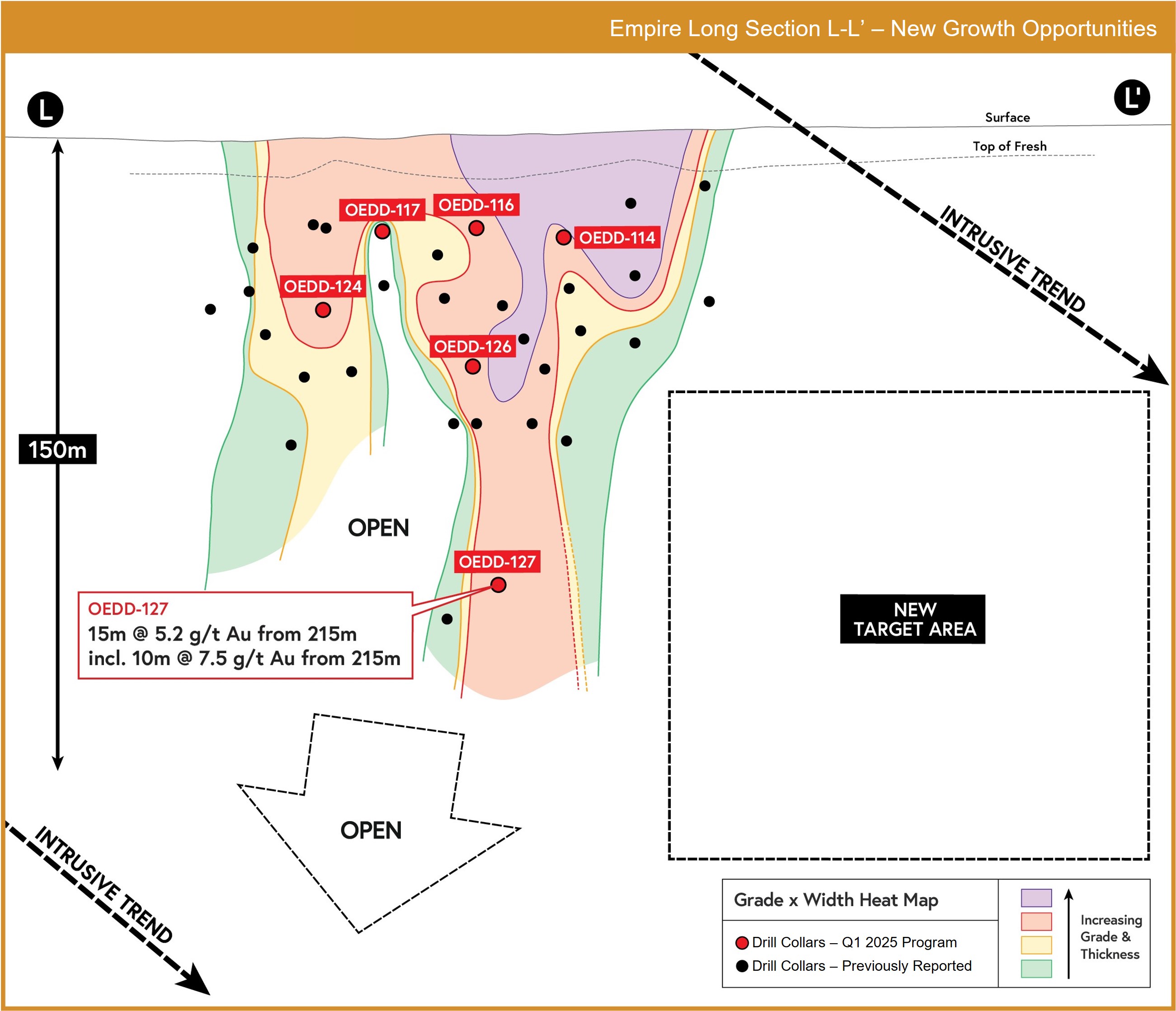
OEDD-127: 15m @ 5.2 g/t Au from 210m downhole,
including 10m @ 7.5 g/t Au from 251m downhole
OEDD-114: 16m @ 3 g/t Au from 44m downhole,
including 5m @ 5.3 g/t Au from 49m downhole
OEDD-124: 19m @ 2.3 g/t Au from 76m downhole,
including 4m @ 6.1 g/t Au
OEDD-126: 39m @ 1.4 g/t Au from 97m downhole,
including 17m @ 2.7 g/t Au from 115m downhole
All holes in the Q1 2025 program intersected significant mineralization, including OEDD-127. The significance of this intercept is that it is located at a similar depth to OEDD-15 and shows the potential of further high-grade mineralization at depth on the Empire Zone.
Exploration to date has partially covered only 5 kilometres of a 20-kilometre trend, with significant potential for further expansion.
Figure 8: A 5 km section of the 20km Long Empire Corridor, and Charger Prospect 2.5km to the North
Figure 7: Visible gold is strongly deformed diorite at Empire Main. Alteration assemblages are potassic (biotite, chlorite clinopyroxene, sericite and silica.
Characteristics
The Empire Main discovery is characterized by multiphase deformation, alteration, and veining with early potassic alteration +/- Au and pyrite, calc silicate alteration (rare garnet, clinopyroxene, and pyrrhotite), carbonate and silica sericite alteration.
The abundant free gold is likely late and associated with the final silica-carbonate-sericite phase.
Figure 9: Empire Long Section
Geological Background
High-grade mineralisation is hosted in brittle/ductile quartz vein arrays that are oriented from east-west to northeast, featuring both shallow and steep plunges.
The host diorite is situated within a brittle/ductile shear zone named the ‘Empire Corridor,’ spanning over 20 kilometres in length and 1 to 2 kilometres in width.
Mineralisation at the Empire Main discovery remains open along both strike and down dip/plunge directions.
Beyond the Empire Main discovery, there exists significant potential for discovering similar or larger deposits along this fertile structural corridor.
Charger Discovery: The Highest-Grade Gold Discovery in Africa in Recent Times
The Charger discovery was first announced in July 2021, and the models and geometry of the mineralization have continued to evolve since then. Multiple phases of drilling have been completed at Charger resulting in numerous high-grade gold intercepts and revealing the NW/NE trending structurally controlled mineralization.
Drilling completed in January 2024 delivered a spectacular intercept of 57m at 26 g/t Au, including 32m at 45.6 g/t Au in drill hole OEDD-83 (see news release dated March 25, 2024). This mineralization was underneath the original discovery hole (OERC-89 – 21m at 2.6 g/t Au and 19.9 g/t Ag from 13m downhole). Follow up drilling confirmed mineralization with step-out and scissor holes returning further excellent results that returned 29m at 20 g/t Au from 149m downhole in OEDD-88 and OEDD-100 with 59m at 14.7 g/t Au (see company news releases dated July 31, 2024 and November 11, 2024, respectively).
Artisanal mining pits at Charger
Selected Results
OERC-89 (Discovery hole)
27m @ 13.6 g/t Ag from 9m downhole
21m @ 2.6 g/t Au from 13m downhole
Including 3m @ 9 g/t Au from 30m downhole
Including 3m @ 89.6 g/t Ag from 30m downhole
Including 2m @ 0.54% Cu from 30m downhole
Including 2m @ 0.29% Pb from 30m downhole
OERC-131: Drilled behind gossan and artisanal workings
10m @ 0.8 g/t Au and 2.1 g/t Ag from 3m downhole
18m @ 0.5 g/t Au and 7.4 g/t Ag from 31m downhole
OERC-132: 40m step-back from OERC-131
32m @ 3.0 g/t Au, 0.17% Cu, and 6.6 g/t Ag from 74m downhole
Including 4m @ 12.4 g/t Au, 0.7% Cu, and 30.5 g/t Ag from 78m downhole
OEDD-45: 3 high-grade intervals within a 65m downhole width of mineralization which included:
12m @ 4.9 g/t Au from 89m downhole
13m @ 1.3 g/t Au from 114m downhole, and
21m @ 1.3 g/t Au from 133m downhole
OEDD-83: 57m @ 26 g/t Au from 164m downhole
Including 32m @ 45.7 g/t Au from 165m downhole
OEDD-84: 70m @ 1.2 g/t Au from 143m downhole
OEDD-85: 21m @ 1.7 g/t Au from 177m downhole and 10m @7.8 g/t Au from 202m downhole
Charger is a high-grade breccia target hosted within a monzodiorite intrusion. The mineralization is controlled by a steeply dipping, northeast-trending structure with internal, wider, and higher-grade shoots that have a sub-horizontal plunge, likely controlled by folding. True widths range from 5 to 40 metres, with the wider zones coinciding with the shallow-plunging, fold-controlled shoots.
The higher-grade zones within the breccia are dominated by hydraulic breccia with quartz-fill and visible gold. Lower grades are generally found in a clinopyroxene matrix breccia, with isolated zones of higher-grade free gold mineralization.
The breccia is zoned both vertically and horizontally (see Long Section). Horizontally, there is a transition from a silica-rich, quartz-fill-dominant hydrothermal breccia on the southeast side to a clinopyroxene-dominant breccia on the northwest side of the northeast-trending structure. Vertically, a polymetallic zone extends from the surface to approximately 100 metres depth, below which there is a transition to a free gold-dominant zone that has yielded consistently high-grade mineralization. This deeper zone contains significantly less sulfide (1–5%).
Alteration is dominated by a combination of silica (quartz), potassic (biotite and K-feldspar), and calc-silicate (clinopyroxene), with hematite and epidote also present. The breccia zones are “magnetite destructive”, where magnetite in the parent rock is overprinted by pyrite and hematite. Dominant sulfides include pyrite, chalcopyrite, and pyrrhotite, with accessory molybdenum, galena, and sphalerite. Tellurides are also present as accessory minerals.
Recent confirmation that mineralization is magnetite destructive opens significant exploration potential at Charger.
Charger Prospect - Drill core showing visible gold [D] and breccia hosted gold and polymetallic mineralisation [A and B] associated with silica sulphide and retrograde chlorite-actinolite-carbonate alteration. Peripheral iron oxide alteration present in the system [C]. Gold grade of the sampled intervals associated with the VG is also shown.
Recent Drilling
Recent drilling in Q4 2024 through Q1 2025 tested the postulated NE corridor along with a fold control on high grade mineralization within this corridor. The drilling has intercepted target geology along strike, above and below the high-grade mineralization intercepts in drill holes OEDD-83, OEDD-88, and OEDD-100.
Beyond confirming mineralization continuity at Charger, the Q1 2025 program yielded the discovery of a parallel zone at Charger.
Hole OEDD-137 intercepted a mineralized breccia 50m from the main Charger corridor, suggesting a similar but separate structure. Five additional target zones have been identified within the Charger host intrusion, these targets are demagnetised zones with geophysical similarities to the current drill area where the Company is currently drilling.
In June 2025, Awalé announced results from four step-back holes (see news release dated June 25, 2025). These latest results extend Charger’s high-grade system 70m deeper, with mineralization now confirmed below 300m. Additional drilling is underway to test down-plunge continuity to 600 metres depth.
Importantly, recent work has defined a parallel zone of mineralization and identified new geophysical targets within the Charger intrusion. These “demagnetized zones” have a geophysical signature consistent with the main Charger breccia and significantly expand Charger’s exploration footprint.
Charger Long Section - On left showing grade and thickness heatmap, with reported holes from June 25, 2025 release shown in red. On right showing planned 3 step-back holes in white, targeting mineralization within a deeper target panel.
A Copper Discovery
Sceptre is a large, 20-km2 copper-gold anomaly, delineated with a combination of Randgold legacy soil geochemistry, infill and extension termitaria & soil sampling by Awalé.
The 5-kilometer-long anomaly is coincident with a major NW trending outcropping structure, the continuity of which has been confirmed from detailed airborne magnetics and ground IP surveys.
The anomaly is zoned with higher copper-molybdenum anomalism toward the east and higher tenor gold to the west. As such, the anomaly has been divided into 3 zones (Figure 13);
– Sceptre East, – Sceptre Main, – and Sceptre West
Sceptre east
Sceptre East encompasses a vast 1.5-kilometer-long copper-gold-molybdenum-silver anomaly situated within porphyritic granodiorite.
It is bordered by shear structures to the north and south, as indicated in the ‘Intrusive Corridor’ in Figure 14.
The north-bounding structure exhibits extraordinarily high chargeability, suggesting significant sulphide development making it a prime target for future drilling. This structure extends northwest toward Sceptre Main and Sceptre West.
The south-sheared boundary runs adjacent to significant coincident Au-Cu anomalism.
Initial drilling efforts have been directed towards this zone.
It is worth noting that the Sceptre East 99th percentile copper anomaly covers the entire 1.5km strike of the Sceptre East anomaly (figure 13), highlighting the immense size of the Sceptre East target which constitutes only 1/3rd of the entire Sceptre system.
Most notably, the mineralisation at Sceptre East exhibits characteristics akin to porphyry-style deposits with molybdenite and chalcopyrite stringer veins accompanied by pyrite (Figure 15).
Figure 15: Sceptre East drill core showing: Vuggy quartz vein infilled with chalcopyrite [A – OEDD-42 64.1m], Molybdenite – Chalcopyrite – Pyrite mineralisation. Molybdenite can commonly develop along foliation and fractures [B - OEDD43 140m] and Chalcopyrite – Pyrite – Molybdenite mineralization associated with silica-sericite alteration [C-OEDD 43 157m].
Figure 16: Cross section looking west through Sceptre East – colours depict copper grades, red hatch is gold. Host is porphyritic granodiorite and intermediate to felsic volcanics.
Hole
From (m)
to (m)
Width (m)
Cu Eq.*
Au (g/t)
Cu (%)
Ag (g/t)
Mo (ppm)
OERC-128
6
126 (EOH)
120
0.29
0.14
0.13
1.5
82
Including
39
52
13
0.43
0.3
0.12
1.6
146
and
78
126
48
0.36
0.11
0.21
2.2
102
OERC-129
11
132 (EOH)
121
0.42
0.21
0.18
2.4
136
Including
30
50
20
0.46
0.3
0.13
1.7
183
and
72
94
22
0.93
0.5
0.43
6.6
171
OERC-130
5
138 (EOH)
133
0.43
0.15
0.13
1.6
312
Including
14
52
38
0.46
0.21
0.13
1.7
284
and
62
90
28
0.48
0.21
0.14
1.9
296.1
* Calculated using Following Prices Au-1737/Oz, Cu 3.6/lb, Ag 21/Oz and Mo 40,000/ tonne (average closing price since 2019)
Using the following formula – Cu+0.7Au+0.0087Ag+0.0006Mo
Table 2: Drill results from discovery drilling phase (reported 29th March 2023)
Figure 13: 5-km-long Cu & Au anomalism in soils and termitaria (Cu left, Au right)
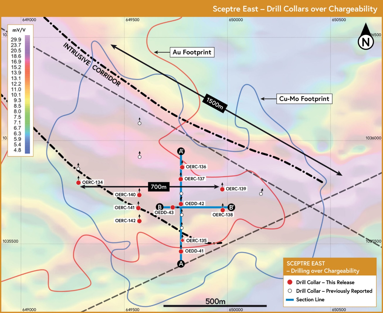
Figure 14: Sceptre East drilling over gradient array induced polarisation chargeability image. Cross sections A-A’ and B-B’ below
Drilling
Discovery drilling commenced at Sceptre East in Q4 2022.
Seven holes for a total of 1,092.2m were drilled in broad (>500m) spaced lines along a 2km stretch of the 5-kilometer-long Sceptre mineralised system (see March 29, 2023 news).
This maiden program tested coincident anomalous gold-copper soil geochemistry and IP Conductivity/Resistivity zones yielding positive results (see November 1, 2022 news).
The drilling delineated an initial strike mineralized zone (>500m) that returned broad and open (>100 meter downhole) mineralised copper-gold-silver and molybdenum intercepts.
Follow-up drilling completed in Q2, 2023 consisted of nine reverse circulation (RC) and three diamond drill holes for a total of 1,730 meters. This drill campaign successfully extended the mineralisation envelope to over 700 m x 300 m. It also revealed broad and open mineralisation.
7 of the 11 holes drilled end in mineralisation (see full table with drill results below).
This phase of drilling included step-out and step-back holes from the initial discovery holes and intercepted chalcopyrite & molybdenite veining, and alteration similar to holes OERC-128, 129 and OERC-130 (see March 29, 2023 news) & (Figure 16).
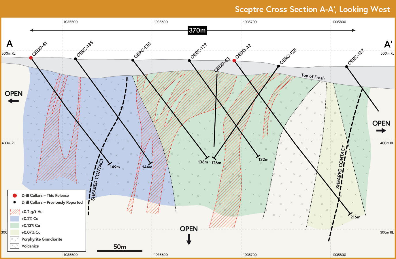
Notably, this phase of drilling recognised prominent south-to-north orientated shears and chalcopyrite-molybdenite bearing vein sets, suggesting previous drilling may have been sub-optimal, and prompting the final deep drill hole (OEDD-43) (Figure 17) to be oriented from west to east.
OEDD-43, the deepest hole to date (365m) intercepted a higher density of chalcopyrite and molybdenite vein sets, with the hole ending in mineralisation with 358.5 m at 0.34% Cu Eq from 6.5 m downhole. Importantly this hole ends in mineralisation to a vertical depth of 275m.
The orientation of the mineralisation appears to be controlled by the WNW-oriented sheared contact between the porphyritic granodiorite and the southern volcanics, as well as NNW to NNE-oriented shears. These orientations will guide future drilling efforts.
Figure 17: Drill section for OEDD-43 at Sceptre East – 358.5m of open mineralisation at 0.34% Cu equivalent.
The Lando Target – Large Au/Cu Soil Geochemical Anomaly
Recent drilling at Lando has confirmed gold and copper mineralization across 2 km of strike within a broader 4-km geochemical trend, reinforcing the target’s potential within the Odienné district. Awalé’s 2,600-metre program in H1 2025 intersected mineralization on all drill lines, with notable results including:
10m @ 1.3 g/t gold from 33m downhole in OELD-01
8m @ 1.1 g/t gold from 183m downhole in OELD-04
29m @ 0.4 g/t gold from 56m downhole in OELR-14
39m @ 0.4 g/t gold from 2m downhole in OELR-15
17m @ 0.7 g/t gold from 17m downhole in OELR-09
1m @ 20.1 g/t gold from 14m downhole in OELR-17
Drilling also revealed two key shear zones—both associated with silica alteration and elevated strain—similar to the mineralizing controls observed at Awalé’s BBM discovery. The presence of felsic intrusive rocks, supported by geophysical data and drill intercepts, points to strong potential for broader and higher-grade mineralized zones at Lando. Follow-up drilling is planned for Q4 2025 to test these zones further and evaluate Lando as a candidate for Awalé’s next major copper-gold discovery.
Figure 19: Core from hole OELD-01
Figure 20: Core from hole OELD-04
Figure 18: Lando Soil Geochemistry - Gold (left) and Copper (right) - Shown with drill lines and selected diamond and RC holes.
Drilling
Recent drilling at Lando has confirmed gold and copper mineralization across 2 km of strike within a broader 4-km geochemical trend, reinforcing the target’s potential within the Odienné district. Awalé’s 2,600-metre program in H1 2025 intersected mineralization on all drill lines, with notable results including:
10m @ 1.3 g/t gold from 33m downhole in OELD-01
8m @ 1.1 g/t gold from 183m downhole in OELD-04
29m @ 0.4 g/t gold from 56m downhole in OELR-14
39m @ 0.4 g/t gold from 2m downhole in OELR-15
17m @ 0.7 g/t gold from 17m downhole in OELR-09
1m @ 20.1 g/t gold from 14m downhole in OELR-17
Drilling also revealed two key shear zones—both associated with silica alteration and elevated strain—similar to the mineralizing controls observed at Awalé’s BBM discovery. The presence of felsic intrusive rocks, supported by geophysical data and drill intercepts, points to strong potential for broader and higher-grade mineralized zones at Lando. Follow-up drilling is planned for Q4 2025 to test these zones further and evaluate Lando as a candidate for Awalé’s next major copper-gold discovery.
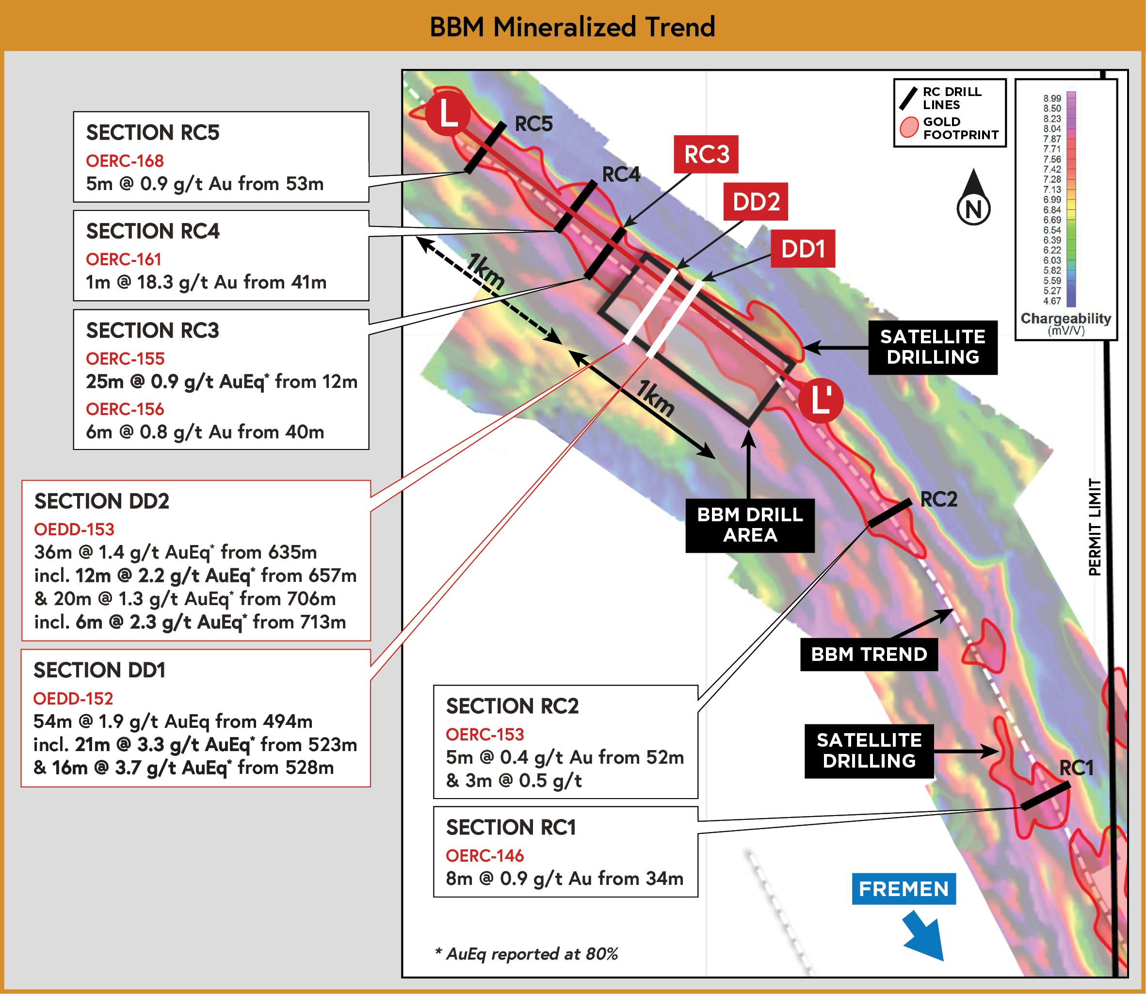
Located approximately 15 km northeast of the Charger target, BBM had no prior exploration or recorded artisanal mining activity before Awalé’s four-hole maiden drill program in December 2024. The target exhibits a significant gold-copper geochemical footprint, comparable in scale and tenor to the Sceptre and Lando prospects.
BBM emerged from Awalé’s evolving understanding of the district geology. Soil and termitaria sampling delineated an open-ended, 8 km-long gold anomaly (+20 ppb Au), which includes a 4 km copper anomaly (>50 ppm Cu; 80th percentile), with a 2 km core zone exhibiting >50 ppb Au and >104 ppm Cu (98th percentile). Peak values within this core reach 1,269 ppb Au and 884 ppm Cu, accompanied by elevated molybdenum and arsenic.
To date, Awalé has completed three phases of drilling at BBM, totaling 50 holes for 13,189 metres. The most recent phase, completed in January 2025, included 22 holes for 6,380 metres (see news releases dated January 29, 2025,February 18, 2025, March 3, 2025, March 18, 2025, and April 8, 2025). Earlier phases were completed during the 2023–2024 field season.
Figure 23: Drill Section A-A’ through holes OEDD-119, OEDD-89, OEDD-97, OEDD-103. Looking toward the NW 50m Window.
Underground Potential
Drilling at BBM has revealed underground potential. Diamond drill holes, OEDD-152 and OEDD-153, have doubled the known depth of mineralization at BBM, returning highly encouraging widths and grades that suggest BBM has underground target potential. Intersections such as 21 metres at 3.3 g/t gold equivalent (see news release dated October 27, 2025) suggest the potential to test down-plunge, alongside the infill drilling planned at BBM as the Company advances toward its first resource estimate in 2026.
Figure 29: The BBM Mineralized Trend, showing gold footprint in red over chargeability.
Geological Background
Mineralization at BBM is hosted within a subtle bend in a shear zone that extends for over 15 km, where Awalé has drilled four scout drill lines in close proximity to BBM (see news release dated April 2, 2025).
The entire structure exhibits anomalous gold and copper geochemistry, supporting its potential as a pipeline for future discoveries.
At the deposit scale, mineralization is characterised by gold-copper-molybdenum occurrences within a high-strain corridor marked by pervasive silica alteration, as well as biotite and k-feldspar/hematite alteration.
Magnetite is also present and is more abundant proximal to mineralization rather than within the higher-grade zones.
Figure 22: BBM Drill Collar Plan, shown over simplified geology.
All drilling at BBM has intersected the target structure across a 2 km strike length, with consistent mineralization in every hole. The discovery zone has returned continuous gold and copper grades over a 1 km strike, now drilled on ~100m spacing to a vertical depth of 300 metres. Several deeper holes confirm that the system remains open down-plunge.
At the core of this zone is a 300-metre-wide, plunging shoot characterized by broader widths and higher-grade mineralization, with average true widths of approximately 30 metres. BBM is now recognized as a significant gold-copper discovery with resource potential and represents a key pillar in Awalé’s district-scale exploration strategy at the Odienné Project.
Figure 24: BBM Long Section L-L’, showing a grade width heatmap. Diamond drill holes OEDD-152 and OEDD-153 show down-plunge continuity of the BBM mineralized system, which is open in all directions. Opportunity also exists for parallel higher-grade shoots as demonstrated by cross section RC3.
Selected Results
Mineralization occurs at the contact between granodiorite and volcanosedimentary rocks and sediments. The presence of molybdenum and other pathfinders share a similar fingerprint to the Charge, Empire, and Sceptre discoveries, where mineralization is thought to have significant magmatic inputs.
Awalé has postulated an Iron Oxide Copper Gold (IOCG) setting for the project area. Lamprophyre dykes proximal and within the mineralization suggest a deep crustal connection for the structures at BBM. The multiple, shallow, broad, high-grade intercepts demonstrate the BBM zone’s excellent continuity and scale potential, and mineralization remains open in all directions.
Selected results from the initial 3 phases at BBM are shown below:
75m @ 2.4 g/t AuEq. from 242m downhole in OEDD-74
44m @ 2.5 g/t AuEq. from 131m downhole in OEDD-65
40m @ 1.9 g/t AuEq. from 194m downhole in OEDD-76
39m @ 1.6 g/t AuEq. from 60m downhole in OEDD-64
44m @ 1.7 g/t AuEq. from 59m downhole in OEDD-59
35m @ 3.3 g/t AuEq. from 318m downhole and 17m @ 2.4 g/t AuEq. in OEDD-89
52m @ 2.0 g/t AuEq. from 181m downhole in OEDD-90
32m @ 2.1 g/t AuEq. from 278m downhole in OEDD-92
27m @ 2.7 g/t AuEq. including 12m @ 3.9 g/t AuEq. In OEDD-98
34m @ 2.4 g/t AuEq. including 12m @ 3.5 g/t AuEq. In OEDD-104
60m @ 1.4g/t AuEq. including 2m @ 4.1g/t AuEq. In OEDD-111
29m @ 2.2 g/t AuEq. including 10m @ 2.4 g/t AuEq. In OEDD-105
52m @ 2.0 g/t AuEq. including 2m @ 8.4 g/t AuEq. In OEDD-119
Figure 25: Core from hole OEDD-74 (75m @ 1.8 g/t Au, 0.3% Cu, and 267 ppm Mo from 242m).
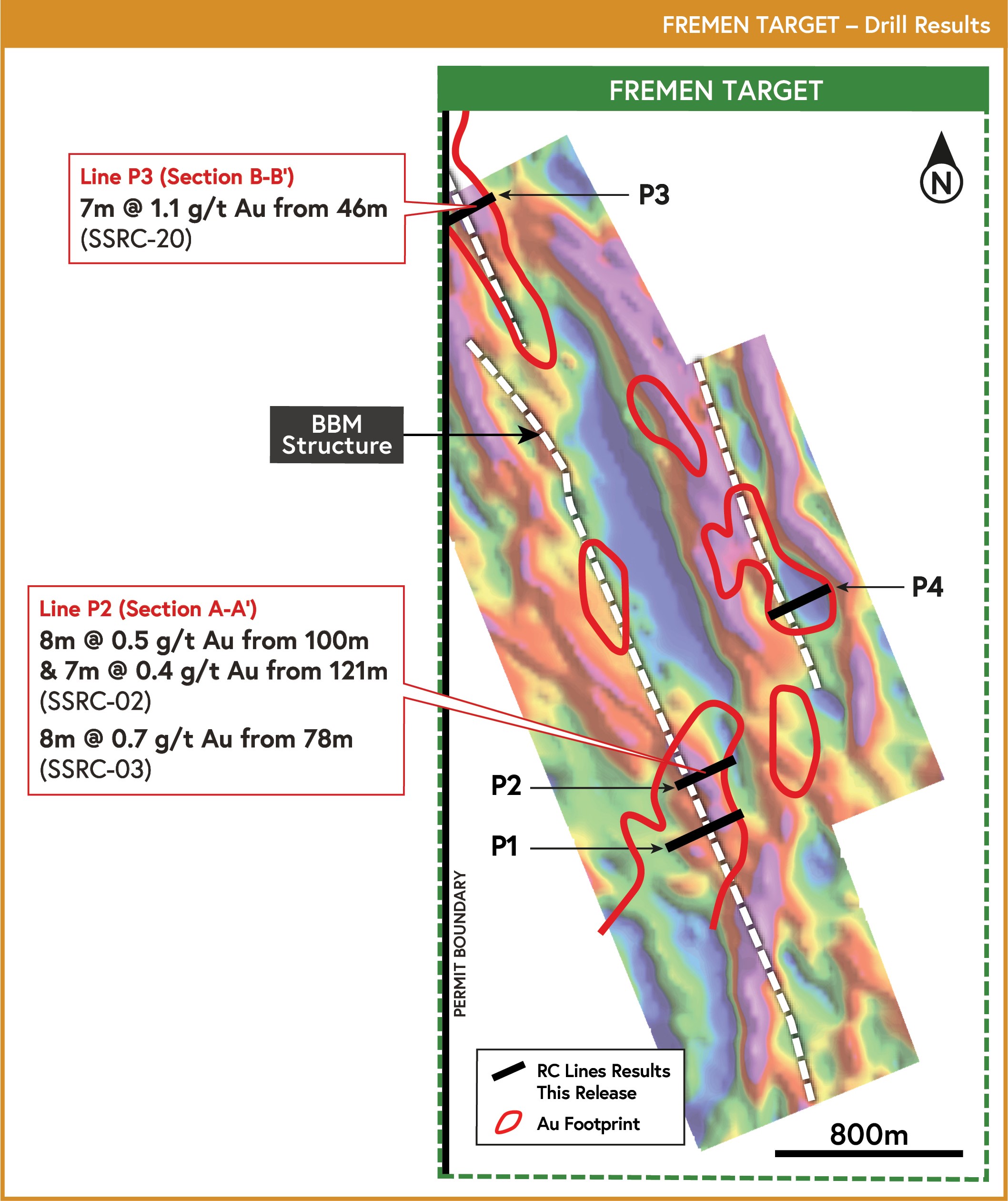
100%-Owned
Fremen is located within the Company’s 100%-owned Sienso permit, just 4 km along strike from the BBM discovery, as indicated in Figure 26.
In October 2024, Awalé announced Fremen consists of a newly uncovered and open 3.5 km-long gold-in-soil and termitaria footprint (>37 ppb Au), with a peak value of 1.3 g/t Au. This was followed by a June 2025 announcement of a 5 km extension to the target, based on termite mound sampling, with scout drilling confirming mineralization along the same structural trend as the BBM discovery—together outlining a gold-mineralized corridor exceeding 10 km.
The scout reverse circulation drill program consisted of 2,230-metres across 24 holes. Gold mineralization intercepted is associated with alteration and shearing, similar to the BBM discovery and represent significant early-stage intercepts over broad intervals coincident with the interpreted extension of the structure that hosts the BBM discovery. Selected intercepts from the Fremen target scout drilling include:
15m @ 0.6 g/t gold from 40m downhole in hole SSRC-20, including 7m @ 1.1 g/t gold from 46m downhole
8m @ 0.5 g/t gold from 100m downhole in hole SSRC-02,
8m @ 0.7 g/t gold from 78m downhole in hole SSRC-03
Figure 27: Fremen anomalous gold geochemistry footprint showing 5 km extension. The BBM structural corridor extends through the Fremen target areas.
Figure 26: Awalé Permits and Targets in NW Côte d’Ivoire.
The IP survey showed chargeable/resistive anomalies that align with the gold footprint, which runs directly along strike from the BBM discovery, as seen in Figure 28.
Figure 28: Induced Polarization ‘Chargeability’ image for Fremen with the gold footprint superimposed in red. Drill lines for the Fremen target are shown as black lines.


![Figure 10: Drill core showing visible gold [D] and breccia hosted gold and polymetallic mineralisation [A and B] associated with silica sulphide and retrograde chlorite-actinolite-carbonate alteration. Peripheral iron oxide alteration present in the system [C]. Gold Grade of the sampled intervals associated with the VG is also shown.](https://i0.wp.com/awaleresources.ca/wp-content/uploads/2023/09/image12-53.png?ssl=1)

![Figure 15: Sceptre East drill core showing: Vuggy quartz vein infilled with chalcopyrite [A – OEDD-42 64.1m], Molybdenite – Chalcopyrite – Pyrite mineralisation. Molybdenite can commonly develop along foliation and fractures [B - OEDD43 140m] and Chalcopyrite – Pyrite – Molybdenite mineralization associated with silica-sericite alteration [C-OEDD 43 157m].](https://i0.wp.com/awaleresources.ca/wp-content/uploads/2023/09/image14-57.png?ssl=1)


