Odienné Project
The Odienné Project is located in the northwest Denguélé Region of Côte d’Ivoire, approximately 600 kilometres
northwest of the commercial capital, Abidjan, and 400 kilometres northwest of the capital, Yamoussoukro.
The Project covers approximately 2,346 square kilometres across seven permits, including the granted Odienné
East, Odienné West, Sienso, Sama, and Seydou permits, as well as two permits under application.
Awalé’s flagship Odienné Project now hosts an initial inferred Mineral Resource Estimate (“MRE”) of 32.4 million
tonnes grading 1.64 g/t gold equivalent for 1.71 million ounces gold equivalent, defined across the BBM, Charger,
and Empire deposits. The resource combines near-surface open pit mineralization at BBM and Empire with high-
grade underground mineralization at Charger and the deeper portions of BBM, providing a strong foundation for
future development studies and resource growth.
The current MRE is located within the Odienné East permit under the Awalé-Newmont exploration agreement,
where Newmont currently funds exploration activities. All deposits remain open along strike and at depth, with
significant potential for additional resource growth through ongoing drilling and future exploration programs.
Beyond the current resource area, Awalé controls a substantial 100%-owned land position across the broader
Odienné district, including the emerging Fremen discovery located 10 kilometres along strike from the BBM
deposit. Recent drilling at Fremen confirmed shallow gold mineralization over an initial 1-kilometre zone within a
broader 8-kilometre mineralized corridor, with geological similarities to both the BBM and Charger discoveries.
Across its 100%-owned permits, Awalé continues to advance multiple geochemical and geophysical targets
prospective for gold and copper-gold mineralization.
The Company believes the geological setting of the district is comparable to other significant Iron Oxide Copper Gold (“IOCG”) and intrusive-related mineral systems globally and continues to see strong potential for additional discoveries and future resource growth across the Project.
Land package
2,346 km²
7 permit land package · Odienné District
Initial MRE
1.71 Moz @ 1.64 g/t AuEq.
Initial Inferred MRE · BBM, Charger & Empire
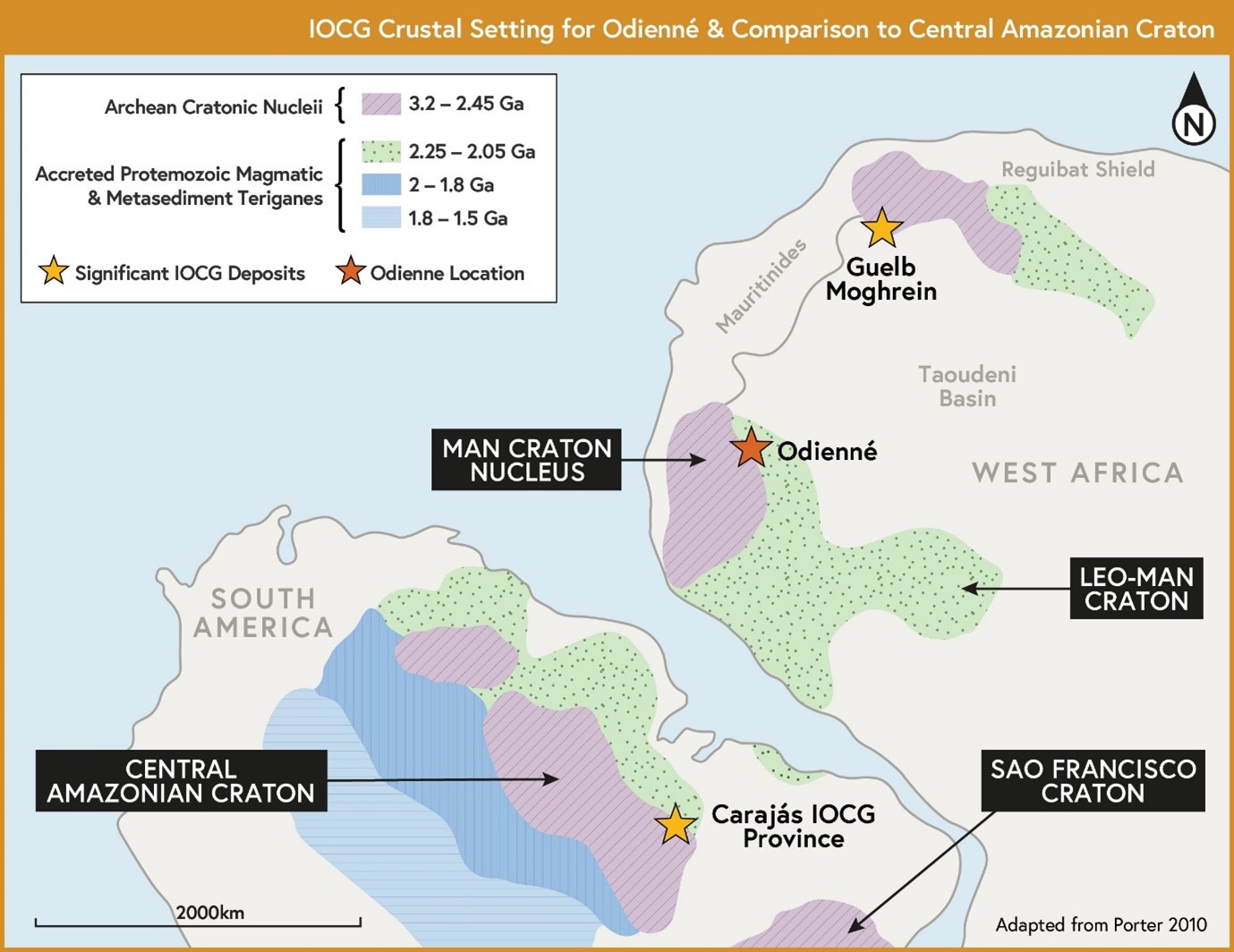
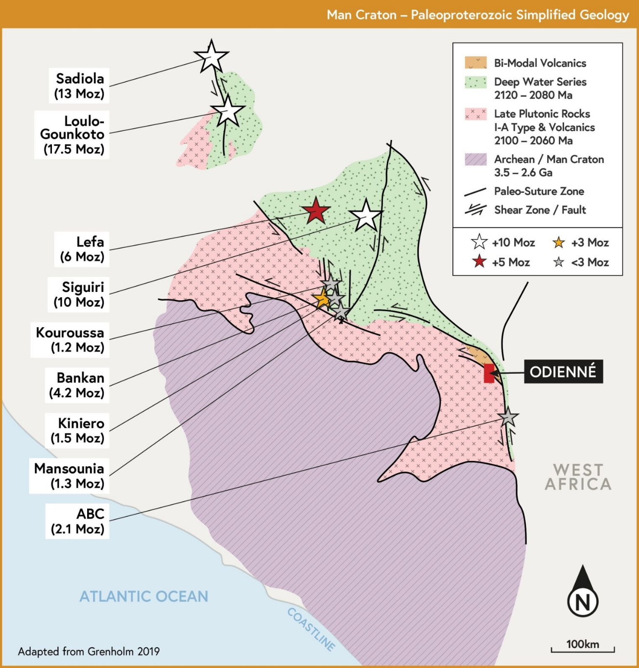
Geological setting
IOCG Setting
Comparable to global copper-gold systems
100%-owned ground
New Discovery
Fremen · 10 km from BBM
100%-Owned Discovery
Fremen is located within the Company’s 100%-owned Sienso permit, just 4 km along strike from the BBM discovery, as indicated in Figure 26.
In October 2024, Awalé announced the Fremen target, a newly uncovered and open 3.5 km-long gold-in-soil and termitaria footprint (>37 ppb Au), with a peak value of 1.3 g/t Au. This was followed by a June 2025 announcement of a 5 km extension to the target, based on termite mound sampling, with scout drilling confirming mineralization along the same structural trend as the BBM discovery—together outlining a gold-mineralized corridor exceeding 10 km.
The scout reverse circulation drill program consisted of 2,230-metres across 24 holes. Gold mineralization intercepted is associated with alteration and shearing, similar to the BBM discovery and represent significant early-stage intercepts over broad intervals coincident with the interpreted extension of the structure that hosts the BBM discovery. Selected intercepts from the Fremen target scout drilling include:
- 15m @ 0.6 g/t gold from 40m downhole in hole SSRC-20, including 7m @ 1.1 g/t gold from 46m downhole
- 8m @ 0.5 g/t gold from 100m downhole in hole SSRC-02,
- 8m @ 0.7 g/t gold from 78m downhole in hole SSRC-03
In May 2026, Awalé announced the discovery of the Fremen gold target. Initial drilling confirmed near-surface gold mineralization over an initial 1 km zone within a broader 8 km mineralized corridor, highlighted by shallow intercepts including:
- 17 metres at 1.9 g/t gold from 6 metres in hole SSAC-08, including 9 metres in at 2.3 g/t gold
- 12 metres at 2.1 g/t gold from 32 metres in hole SSAC-07, including 1 metre at 8.0 g/t gold
Diamond drilling also confirmed mineralization at depth, including 17 metres at 1.1 g/t gold from 113 metres in hole SSDD-03.
Fremen shares key geological characteristics with Awalé’s BBM and Charger discoveries, including similar alteration, structural controls, and intrusive associations, reinforcing management’s view that the target has the potential to evolve into another significant discovery within the broader Odienné district. With results still pending from additional drill holes and the broader corridor remaining open, Fremen represents a new growth opportunity on Awalé’s fully owned ground.
Mineral Resource Estimate
Initial MRE 2026
Highlights
- 32.4 Mt grading 1.64 g/t gold equivalent (“AuEq.”) for 1,707,000 ounces (“oz”) gold equivalent inferred from combined open pit and underground resources, including 1,389,000 oz gold and 93,380 tonnes copper.
- BBM forms the cornerstone deposit with combined open pit and underground resources of 27.8 Mt at 1.52 g/t AuEq. for 1,356,000 oz gold equivalent (1.16 g/t gold and 0.33% copper).
- Charger defines a high-grade underground resource of 1.6 Mt at 4.64 g/t AuEq. for 232,000 oz gold equivalent.
- Empire contributes a near-surface open pit resource of 3.0 Mt at 1.23 g/t gold for 119,000 oz gold.
- Strong potential for resource growth and conversion from inferred to indicated through ongoing infill and expansion drilling near existing deposits.
- MRE forms the foundation for a Preliminary Economic Assessment targeted for Q3 2026 and a Pre-Feasibility Study in Q4 2027.
With a substantial resource of 1.71 Moz AuEq. at a robust average grade of 1.64 g/t AuEq. across the BBM, Charger, and Empire deposits, this MRE establishes Odienné as a significant gold-copper project. (see Table 1)
The resource combines near-surface open pit mineralization at BBM and Empire with high-grade underground mineralization at Charger and deeper portions of BBM, providing development flexibility as we advances toward a Preliminary Economic Assessment targeted for Q3 2026.
All deposits remain open along strike and at depth, with strong potential for resource growth through planned plunge and extension drilling at these targets.
The MRE reflects a combined open pit and underground mining scenario, with BBM contributing both open pit and underground gold and copper resources, Charger is defined as a high-grade gold underground resource, and Empire as a near-surface open pit gold resource.The resource captures multiple styles of mineralization across the Odienné Project, highlighting the scale, continuity, and evolving understanding of this district-scale gold-copper system. All deposits remain open along strike and at depth, collectively providing significant potential for future resource growth and advancement of the Project.
The MRE has been constrained using conceptual mining shapes and appropriate cut-off grades for both open pit and underground scenarios, reflecting reasonable prospects for eventual economic extraction (“RPEEE”) in accordance with NI 43-101 guidelines. RPEEE assumptions, including cut-off grades, metallurgical recoveries, and cost parameters, are summarized in Table 2. The RPEEE assumptions used in the resource model incorporate metal prices that are conservative relative to current market conditions, providing a disciplined framework for early-stage evaluation.
The planned PEA targeted for Q3 2026 will further evaluate project economics and sensitivities, including the impact of metal prices, mining methods, and potential development scenarios for the Odienné Project.In establishing this initial MRE, the focus has been on defining a robust, high-quality resource base across multiple deposits, balancing near-surface open pit opportunities with higher-grade underground potential. Ongoing and future work will prioritize resource growth, conversion to higher confidence categories, and optimization of mining scenarios as the Company advances the Project through future development studies.
Table 1: NI 43-101 Mineral Resource Estimate by Deposit – Odienné Project
| Deposit | Category | Type | Tonnes (Mt) | Grade | Contained Metal | ||||
|---|---|---|---|---|---|---|---|---|---|
| AuEq. (g/t) | Au (g/t) | Cu (%) | AuEq. (oz) | Au (oz) | Cu (tonnes) | ||||
| BBM | Inferred | Open Pit | 21.5 | 1.37 | 1.03 | 0.32 | 947,000 | 714,000 | 68,000 |
| Inferred | Underground | 6.3 | 2.01 | 1.60 | 0.39 | 409,000 | 325,000 | 25,000 | |
| Inferred | Combined | 27.8 | 1.52 | 1.16 | 0.33 | 1,356,000 | 1,039,000 | 93,000 | |
| Charger | Inferred | Underground | 1.6 | 4.64 | 4.62 | 0.02 | 232,000 | 231,000 | 380 |
| Empire | Inferred | Open Pit | 3.0 | 1.23 | 1.23 | - | 119,000 | 119,000 | - |
| Global Total | Inferred | Combined | 32.4 | 1.64 | 1.33 | 0.33 | 1,707,000 | 1,389,000 | 93,380 |
Notes to the Mineral Resource Estimate:
- Tonnages are reported to the nearest 100,000t to reflect these as estimates.
- Metal content is rounded to the nearest 1,000ozs (Au) and 1,000t (Cu) to reflect these as estimates.
- A gold equivalence has been calculated which incorporates the following inputs; pricing of US$3,000/oz Au and US$4.34/lb Cu and gold recoveries of 94%, 91%, and 86% for Empire, Charger, and BBM respectively, and copper recoveries of 63%, 94%, and 93% for Empire, Charger, and BBM respectively, based on the averages of current metallurgical testwork results.
- Au Equivalent equations; AuEq. g/t = (1 x Au) + (1.007324 x Cu%) for Charger and AuEq. g/t = (1 x Au) + (1.065793 x Cu%) for BBM.
- Mineral Resources are not Mineral Reserves and do not have demonstrated economic viability.
- Tonnage is estimated by applying average SG by rock/mineralization type for each deposit, derived from a total dataset of 10,278 samples. Assigned SG’s of 1.90 (saprolite), 2.75 (granodiorite, int volcanics), 2.82 (qtz breccia), 2.83 (metasediments, monzodiorite), and 2.86 (actinolite breccia) have been assigned to blocks in the models.
- Open Pit Mineral Resources are reported above a cut-off grade of 0.32 g/t AuEq. within conceptual pit shells, and underground Mineral Resources report all blocks within conceptual volumes generated from mineable shape optimiser (MSO) software incorporating an in-situ cut-off grade of 1.28 g/t AuEq., to support reasonable prospects for eventual economic extraction (RPEEE) as per the CIM Estimation of Mineral Resources and Mineral Reserves Best Practice Guidelines prepared by the CIM Mineral Resource and Mineral Reserve Committee and adopted by the CIM Council on November 29, 2019. RPEEE assumptions and parameters, which the QP considers reasonable, are set out in Table 2.
- The QP is not aware of any legal, permitting, title, taxation, socio-economic, marketing, political, environmental or other risk factors that might materially affect the estimate of Mineral Resources.
Mineral Resource Methodology, Assumptions, and Cut-Off Grades
The BBM mineral resource estimate utilizes data collected from 85 diamond drill (“DD”) holes and 28 reverse circulation (“RC”) holes, totalling 30,173 metres (“m”) of drilling, of which 21,805m have been assayed for gold and 21,432m assayed for copper. The drilling intercepts the mineralization on approximately an 80m to 100m grid.
The Charger mineral resource estimate utilizes data collected from 64 DD holes and 30 RC holes, totalling 22,343m of drilling, of which 17,673m have been assayed for gold and 15,151m assayed for copper. The drilling intercepts the mineralization 20m to 30m along strike and 40m in the down-dip direction.
The Empire mineral resource estimate utilizes data collected from 45 DD holes and 99 RC holes, totalling 15,939m of drilling, of which 15,753m have been assayed for gold. The current drill hole spacing is variable, ranging from 20m to 40m within the mineral resource area, with drill hole line spacing opening up to 100m towards the east.
The geological models for all deposits were constructed in Leapfrog software utilizing geological logs and guided by, and honouring cross sectional geological interpretation with 3D visualization and validation.
The BBM geological model comprises primarily of two lithology units, a hanging wall granodiorite and footwall metasediments. The contact is characterized by two, northwest plunging fold structures. Mineralization is associated with this geological contact, occurring predominantly within the granodiorites and locally extending into the footwall metasediments. The mineralization thickness ranges from less than a metre, up to 40m and tends to narrow along the fold hinges.
The Charger geological model comprises of a narrow, vertically dipping quartz breccia unit hosted within monzodiorite and intermediate volcanics, striking southwest-northeast (SW-NE) with thicknesses ranging between 1m and 20m. Gold mineralization occurs primarily within the quartz and actinolite rich breccias.
The Empire geological model consists of a main diorite intrusion with an east-west strike length of 240m which abuts against a series of anastomosing porphyry dykes. The gold mineralization is largely confined within these two units, locally extending beyond the geological contact. A second diorite intrusion occurs 60m to the south. The mineralized zones are steeply dipping, with thickness ranging from less than a metre up to 30m thick.
Mineralized zones were modelled at a nominal 0.20 g/t Au threshold.
3D block models were prepared for each deposit, constructed using parent cell dimensions of 20 mX by 10 mY by 20 mZ (BBM), 10 mX by 10 mY by 10 mZ (Charger), and 20 mX by 10 mY by 10 mZ (Empire) with subcelling (to optimally file wireframes) down to 1 mX by 0.5 mY by 1 mZ (BBM), 0.5 mX by 0.5 mY by 1 mZ (Charger) and 0.5 mX by 0.5 mY by 0.5 mZ (Empire). Assay data was composited to 2m intervals within the mineralized domains and appropriate capping was used to limit the influence of outliers in the estimates. Statistical and geostatistical analysis was completed to determine directions and ranges of grade continuity and inform the estimation parameters. Grades were estimated into parent cells via Ordinary Kriging (OK) in three passes of increasing search volumes until all blocks received a grade estimate. A search volume informed by the semivariogram ranges was applied during the estimates which was locally orientated using Dynamic Anisotropy. Average densities were assigned to each modelled by rock type. Block model validations undertaken include comparing the mean grades of the input composite data against the block grades, swath plots, volume checks, and visual validations.
Reasonable prospects of eventual economic extraction (“RPEEE”) is justified via the reporting of open pit mineral resources within a conceptual pit shell at a cut-off grade of 0.32 g/t AuEq., and underground mineral resources reported within volumes generated from mineable shape optimiser (MSO) software, incorporating an in-situ cut-off grade of 1.34 g/t AuEq. (BBM) and 1.28 g/t AuEq. (Charger), a minimum and maximum stope width of 3m and 15m respectively and a stope length of 20m.
The mineral resource classification is supported by adequately spaced exploration drilling, well understood geology, appropriate QA/QC controls, robust estimation domains and geostatistical analysis which collectively are sufficient basis to infer geological and grade continuity for classification as inferred mineral resources.
Table 2: Parameters Used for 'RPEEE' Constrained Resource Estimate
| Parameters | Unit | Value | |
|---|---|---|---|
| Gold Price | US$/oz | 3,000 | |
| Charger | % | 99.0 | |
| Royalty | % | 8.0 | |
| Recovery by Deposit | |||
| BBM | % | 86.0 | |
| Charger | % | 91.4 | |
| Empire | % | 94.1 | |
| Conceptual Mining Parameters | |||
| Open Pit | Underground | ||
| Mining Cost - Mineralized Material | |||
| BBM | US$/t mined | 4.23 + 0.005/m | 70.00 |
| Charger | US$/t mined | - | 70.00 |
| Empire | US$/t mined | 5.00 | - |
| Mining Cost -Waste | |||
| BBM | US$/t mined | 3.47 + 0.005/mm | - |
| Empire | US$/t mined | 5.00 | - |
| G&A Cost | |||
| US$/t milled | 2.50 | 2.50 | |
| Processing and Tailings Cost | |||
| US$/t milled | 21.00 | 21.00 | |
| Haulage to Plant Cost | |||
| Charger & Empire | US$/t milled | 2.66 | 2.66 |
| Pit Slopes | |||
| Pit Slope in Rock | degrees | 55 | - |
| Pit Slope in Transitional | degrees | 45 | - |
| Pit Slope in Overburden | degrees | 40 | - |
| Mining Recovery / Dilution | % | 5x5x5 Reblock | 90%/10% |
| Reporting Cut-Off Grade | BBM | AuEq. g/t | 0.32 | 1.34 |
| Charger | AuEq. g/t | - | 1.28 |
| Empire | AuEq. g/t | 0.32 | - |
Mineral Resource Sensitivities
Mineral resources at various cut-off grades are presented below for the BBM open pit and underground resources, the Charger underground resources, and the Empire open pit resources. The mineral resources are reported within conceptual open pit shells and underground mineable shape optimizer (“MSO”) shapes generated using assumptions and parameters considered appropriate to support RPEEE. The reporting cut-off grades applied to the mineral resource estimates are 0.32 g/t AuEq. for the BBM open pit resources, 1.34 g/t AuEq. for the BBM underground resources, 1.28 g/t AuEq. for the Charger underground resources, and 0.32 g/t Au for the Empire open pit resources. The sensitivity tables demonstrate the robustness of the mineral resource estimates across a range of cut-off grades.
BBM
The BBM deposit forms the cornerstone of the initial mineral resource estimate, contributing a combined open pit and underground inferred resource of 27.8 Mt grading 1.52 g/t AuEq. for 1.36 Moz AuEq., including 1.04 Moz Au and 93,000 tonnes of contained copper. The cut-off grade used for the MRE is highlighted.
Table 3: BBM – Open Pit Resource C.O.G. Sensitivity
| Cut-Off Grade (g/t AuEq.) |
Tonnes (t) |
Grade (g/t AuEq.) |
AuEq. Resource (oz) |
|---|---|---|---|
| 0.20 | 21,500,000 | 1.37 | 947,000 |
| 0.30 | 21,500,000 | 1.37 | 947,000 |
| 0.32 | 21,500,000 | 1.37 | 947,000 |
| 0.40 | 21,300,000 | 1.38 | 945,000 |
| 0.50 | 20,600,000 | 1.41 | 934,000 |
| 0.60 | 19,300,000 | 1.47 | 911,000 |
| 0.70 | 17,900,000 | 1.53 | 881,000 |
| 0.80 | 16,400,000 | 1.60 | 845,000 |
| 0.90 | 14,900,000 | 1.68 | 805,000 |
Table 4: BBM – Underground Resource C.O.G. Sensitivity
| Percentage Change | Cut-Off Grade (g/t AuEq.) |
Tonnes (Mt) |
Grade (g/t AuEq.) |
AuEq. Resource (oz) |
|---|---|---|---|---|
| -20% | 1.07 | 9.6 | 1.71 | 531,000 |
| -10% | 1.21 | 8.0 | 1.83 | 473,000 |
| Base Case | 1.34 | 6.3 | 2.01 | 409,000 |
| +10% | 1.47 | 5.2 | 2.12 | 351,000 |
| +20% | 1.61 | 4.3 | 2.24 | 308,000 |
charger
The Charger deposit defines a high-grade underground inferred resource of 1.6 Mt grading 4.64 g/t AuEq. for 232,000 oz AuEq. The cut-off grade used for the MRE is highlighted.
Table 5: Charger – Underground Resource C.O.G. Sensitivity
| Percentage Change | Cut-Off Grade (g/t AuEq.) |
Tonnes (Mt) |
Grade (g/t AuEq.) |
AuEq. Resource (oz) |
|---|---|---|---|---|
| -20% | 1.02 | 1.9 | 4.05 | 243,000 |
| -10% | 1.15 | 1.7 | 4.37 | 238,000 |
| Base Case | 1.28 | 1.6 | 4.64 | 232,000 |
| +10% | 1.41 | 1.5 | 4.87 | 228,000 |
| +20% | 1.54 | 1.4 | 5.10 | 223,000 |
empire
The Empire deposit contributes a near-surface open pit inferred resource of 3.0 Mt grading 1.23 g/t Au for 119,000 oz Au. The cut-off grade used for the MRE is highlighted.
Table 6: Empire – Open Pit Resource C.O.G. Sensitivity
| Cut-Off Grade (g/t Au) |
Tonnes (t) |
Grade (g/t Au) |
AuEq. Resource (oz) |
|---|---|---|---|
| 0.20 | 3,100,000 | 1.20 | 120,000 |
| 0.30 | 3,000,000 | 1.23 | 119,000 |
| 0.32 | 3,000,000 | 1.23 | 119,000 |
| 0.40 | 2,900,000 | 1.26 | 117,000 |
| 0.50 | 2,600,000 | 1.36 | 113,000 |
| 0.60 | 2,300,000 | 1.44 | 109,000 |
| 0.70 | 2,200,000 | 1.50 | 105,000 |
| 0.80 | 2,000,000 | 1.59 | 100,000 |
| 0.90 | 1,800,000 | 1.67 | 95,000 |
A Copper Discovery
Sceptre is a large, 20-km2 copper-gold anomaly, delineated with a combination of Randgold legacy soil geochemistry, infill and extension termitaria & soil sampling by Awalé.
The 5-kilometer-long anomaly is coincident with a major NW trending outcropping structure, the continuity of which has been confirmed from detailed airborne magnetics and ground IP surveys.
The anomaly is zoned with higher copper-molybdenum anomalism toward the east and higher tenor gold to the west. As such, the anomaly has been divided into 3 zones (Figure 13);
– Sceptre East,
– Sceptre Main,
– and Sceptre West
Sceptre east
Sceptre East encompasses a vast 1.5-kilometer-long copper-gold-molybdenum-silver anomaly situated within porphyritic granodiorite.
It is bordered by shear structures to the north and south, as indicated in the ‘Intrusive Corridor’ in Figure 14.
The north-bounding structure exhibits extraordinarily high chargeability, suggesting significant sulphide development making it a prime target for future drilling. This structure extends northwest toward Sceptre Main and Sceptre West.
The south-sheared boundary runs adjacent to significant coincident Au-Cu anomalism.
Initial drilling efforts have been directed towards this zone.
It is worth noting that the Sceptre East 99th percentile copper anomaly covers the entire 1.5km strike of the Sceptre East anomaly (figure 13), highlighting the immense size of the Sceptre East target which constitutes only 1/3rd of the entire Sceptre system.
Most notably, the mineralisation at Sceptre East exhibits characteristics akin to porphyry-style deposits with molybdenite and chalcopyrite stringer veins accompanied by pyrite (Figure 15).
Hole | From (m) | to (m) | Width (m) | Cu Eq.* | Au (g/t) | Cu (%) | Ag (g/t) | Mo (ppm) |
OERC-128 | 6 | 126 (EOH) | 120 | 0.29 | 0.14 | 0.13 | 1.5 | 82 |
Including | 39 | 52 | 13 | 0.43 | 0.3 | 0.12 | 1.6 | 146 |
and | 78 | 126 | 48 | 0.36 | 0.11 | 0.21 | 2.2 | 102 |
OERC-129 | 11 | 132 (EOH) | 121 | 0.42 | 0.21 | 0.18 | 2.4 | 136 |
Including | 30 | 50 | 20 | 0.46 | 0.3 | 0.13 | 1.7 | 183 |
and | 72 | 94 | 22 | 0.93 | 0.5 | 0.43 | 6.6 | 171 |
OERC-130 | 5 | 138 (EOH) | 133 | 0.43 | 0.15 | 0.13 | 1.6 | 312 |
Including | 14 | 52 | 38 | 0.46 | 0.21 | 0.13 | 1.7 | 284 |
and | 62 | 90 | 28 | 0.48 | 0.21 | 0.14 | 1.9 | 296.1 |
* Calculated using Following Prices Au-1737/Oz, Cu 3.6/lb, Ag 21/Oz and Mo 40,000/ tonne (average closing price since 2019) | ||||||||
Using the following formula – Cu+0.7Au+0.0087Ag+0.0006Mo | ||||||||
Table 2: Drill results from discovery drilling phase (reported 29th March 2023)
Drilling
Discovery drilling commenced at Sceptre East in Q4 2022.
Seven holes for a total of 1,092.2m were drilled in broad (>500m) spaced lines along a 2km stretch of the 5-kilometer-long Sceptre mineralised system (see March 29, 2023 news).
This maiden program tested coincident anomalous gold-copper soil geochemistry and IP Conductivity/Resistivity zones yielding positive results (see November 1, 2022 news).
The drilling delineated an initial strike mineralized zone (>500m) that returned broad and open (>100 meter downhole) mineralised copper-gold-silver and molybdenum intercepts.
Follow-up drilling completed in Q2, 2023 consisted of nine reverse circulation (RC) and three diamond drill holes for a total of 1,730 meters. This drill campaign successfully extended the mineralisation envelope to over 700 m x 300 m. It also revealed broad and open mineralisation.
7 of the 11 holes drilled end in mineralisation (see full table with drill results below).
This phase of drilling included step-out and step-back holes from the initial discovery holes and intercepted chalcopyrite & molybdenite veining, and alteration similar to holes OERC-128, 129 and OERC-130 (see March 29, 2023 news) & (Figure 16).
Notably, this phase of drilling recognised prominent south-to-north orientated shears and chalcopyrite-molybdenite bearing vein sets, suggesting previous drilling may have been sub-optimal, and prompting the final deep drill hole (OEDD-43) (Figure 17) to be oriented from west to east.
OEDD-43, the deepest hole to date (365m) intercepted a higher density of chalcopyrite and molybdenite vein sets, with the hole ending in mineralisation with 358.5 m at 0.34% Cu Eq from 6.5 m downhole. Importantly this hole ends in mineralisation to a vertical depth of 275m.
The orientation of the mineralisation appears to be controlled by the WNW-oriented sheared contact between the porphyritic granodiorite and the southern volcanics, as well as NNW to NNE-oriented shears. These orientations will guide future drilling efforts.
The Lando Target – Large Au/Cu Soil Geochemical Anomaly
Recent drilling at Lando has confirmed gold and copper mineralization across 2 km of strike within a broader 4-km geochemical trend, reinforcing the target’s potential within the Odienné district. Awalé’s 2,600-metre program in H1 2025 intersected mineralization on all drill lines, with notable results including:
- 10m @ 1.3 g/t gold from 33m downhole in OELD-01
- 8m @ 1.1 g/t gold from 183m downhole in OELD-04
- 29m @ 0.4 g/t gold from 56m downhole in OELR-14
- 39m @ 0.4 g/t gold from 2m downhole in OELR-15
- 17m @ 0.7 g/t gold from 17m downhole in OELR-09
- 1m @ 20.1 g/t gold from 14m downhole in OELR-17
Drilling also revealed two key shear zones—both associated with silica alteration and elevated strain—similar to the mineralizing controls observed at Awalé’s BBM discovery. The presence of felsic intrusive rocks, supported by geophysical data and drill intercepts, points to strong potential for broader and higher-grade mineralized zones at Lando. Follow-up drilling is planned for Q4 2025 to test these zones further and evaluate Lando as a candidate for Awalé’s next major copper-gold discovery.
Drilling
Recent drilling at Lando has confirmed gold and copper mineralization across 2 km of strike within a broader 4-km geochemical trend, reinforcing the target’s potential within the Odienné district. Awalé’s 2,600-metre program in H1 2025 intersected mineralization on all drill lines, with notable results including:
- 10m @ 1.3 g/t gold from 33m downhole in OELD-01
- 8m @ 1.1 g/t gold from 183m downhole in OELD-04
- 29m @ 0.4 g/t gold from 56m downhole in OELR-14
- 39m @ 0.4 g/t gold from 2m downhole in OELR-15
- 17m @ 0.7 g/t gold from 17m downhole in OELR-09
- 1m @ 20.1 g/t gold from 14m downhole in OELR-17
Drilling also revealed two key shear zones—both associated with silica alteration and elevated strain—similar to the mineralizing controls observed at Awalé’s BBM discovery. The presence of felsic intrusive rocks, supported by geophysical data and drill intercepts, points to strong potential for broader and higher-grade mineralized zones at Lando. Follow-up drilling is planned for Q4 2025 to test these zones further and evaluate Lando as a candidate for Awalé’s next major copper-gold discovery.
Introduction
The greater Odienné Project lies in the northwest Denguélé Region of Côte d’Ivoire, approximately 600 kilometres northwest of the commercial capital, Abidjan, and approximately 400 kilometres northwest of the capital, Yamoussoukro.
The project covers approximately 2,346 square kilometres in 7 permits – the granted Odienné East, Odienné West, Sienso, Sama, and Seydou permits and 2 permits under application (Figure 1 and Figure 2, Table 1).
Previous Exploration
The Odienné project area was subject to previous first-pass exploration geochemistry in the mid-1990s through a joint venture between SODEMI and Randgold Resources. They completed shallow, broad-spaced soil sampling for gold and base metals over the greater portion of the project area and followed up with pitting and trenching. Significant anomalism was recognised across the sampled area which covered some 300 km2.
After that, infill geochemical sampling and mapping was completed over multiple targets. Despite returning significant gold and base metal anomalies, no follow-up drilling was completed.
In late 2017, Awalé initiated its involvement in the Odienné Project by acquiring an initial 2 permits from Aforo Resources – an Australian company – in partnership with their local associate – ANGET – who still retains a 10% interest.
Following this acquisition, Awalé embarked on a systematic exploration campaign that incorporated valuable legacy data from Randgold Resources. This initial prospection encompassed various activities, including permit-wide BLEG stream sediment sampling, and targeted mapping and geochemical sampling and analyses over Empire, Vakaba, and Lancer. This diligent exploration endeavour culminated in the commencement of drilling activities at the Empire and Vakaba targets, ultimately leading to the significant discovery of high-grade gold at the Empire Target.
Notably, during this phase of exploration, the drilling operations at Empire extended through 2021, resulting in the return of multiple high-grade intercepts exceeding +100 gram-meters, as elaborated in the Empire discussion below.
Additionally, at the Vakaba target, narrow intervals of visible gold were encountered within quartz tourmaline veins, further highlighting the project’s Mineralisation potential.
Newmont Partnership
The district-scale approach adopted by Awalé, combined with the impressive high-grade results being returned from drilling immediately attracted interest from Newmont, the world’s largest gold producer.
In October 2021, Newmont conducted multiple site visits and commenced a due diligence process, meticulously analyzing the data. This culminated in the signing of an Earn-In Joint Venture over two permits (Odienné East & Odienné West) in July 2022 (see May 31, 2022 news release).
Under the agreement, Newmont has the opportunity to earn up to 65% ownership of the permits through exploration expenditure totaling $US15 million, along with an option to purchase 10% held by local partner ANGET.
Today, Newmont is not only a joint-venture partner of ours, they are a very hands-on shareholder of Awalé Resources, who visits the project on a regular basis (see Figure 3A). The shared vision between Awalé and Newmont underscores the potential for the discovery of a ‘Tier 1’ asset on the Odienné Project.
Geological Significance
Awalé is confident the geological setting of the Odienné district to be comparable to that of other significant Iron Oxide Copper Gold (IOCG) provinces globally.
IOCG deposits are significant contributors to global copper and gold inventories, and the Company considers the Odienné Project to contain significant potential for the discovery of the first major IOCG deposit in west Africa.
| Ownership | Permit Type | Permit Number | Area — Square km |
|---|---|---|---|
| Awalé-Newmont JV | Granted | PR — 419 “Odienné East” | 397.2 |
| Granted | PR — 904 “Odienné West” | 399.4 | |
| 100% Awalé Resources | |||
| Granted | PR — 840 “Sienso” | 244.8 | |
| Granted | PR — 992 “Seydou” | 390.6 | |
| Application | 0729DMICM — “GB” | 247.2 | |
| Granted | PR — 991 “Sama” | 296.0 | |
| Application | 0579DMICM — “Tienko” | 371.2 |
Table 1: List Of Odienné Project Permits & Applications
Empire Gold Discovery
After discovering high-grade gold at Empire Main, the Charger target was also drilled with a similar mineralization model envisaged.
However, hematite breccias with copper and gold mineralization were intercepted, sparking the concept for potential Iron Oxide Copper Gold (IOCG) style mineralization.
This significant development prompted a revisit to both Randgold legacy and company data which included base metal analysis. The result was a comprehensive reinterpretation leading to the adoption of an IOCG model as part of Awalé’s systematic exploration strategy for the project.
Additionally, and significantly, this work resulted in the recognition of the 20 km2 Sceptre target and marked a shift toward the Odienné Project as a primary focus for the company.
Exploration Model
Awalé has recognised the significance of the crustal setting of the Odienné Project and the associated Cu-Au Mineralisation that characterises the district.
Consequently, a hybrid Orogenic/Iron Oxide Copper Gold (IOCG) model has been adopted for further exploration.
Targets & Prospects
Current targets for this style of Mineralisation Include the Sceptre, Charger, Lando, and BBM Prospects (figure 3).
Sceptre is a significant 5-km-long high-tenor Cu-Au IOCG geochemical target which now boasts significant broad copper-gold, molybdenum, and silver intercepts in recent drilling (see Sceptre tab).
Charger and Empire are both high-grade gold targets with multiple intercepts exceeding 100 gram – meters in both RC and diamond drilling.
Geological Setting
The Odienné project is situated on a significant Archean-Proterozoic age margin.
Awalé interprets this geological setting as comparable to that of other prominent Iron Oxide Copper Gold (IOCG) provinces globally.
IOCG deposits are significant contributors to global copper and gold inventories, and Awalé considers the Odienné project to contain significant potential for the discovery of the first major IOCG deposit in West Africa.
Similarities
The similarities in Odienné crustal setting to the Major Olympic Dam and Carajás IOCG provinces in Australia and Brazil are compelling.
The Sceptre, Sceptre East, and Charger Prospects exhibit similar characteristics like late bimodal intrusions, coeval undeformed bimodal volcanic rocks, and hematite breccias within magnetite-altered diorite at the Charger Prospect.
These features, coupled with the Cu-Au and Silver Mineralisation and the polymetallic zonation containing pathfinder elements typically associated with IOCG systems (including bismuth, silver, molybdenum, and tungsten), provide strong evidence for comparison to major global IOCG provinces.
Precambrian IOCG Provinces
Globally renowned Precambrian IOCG provinces (such as Olympic Dam in the Gawler Craton, Australia, and Carajás in the Amazonian Craton, Brazil) are important sources of copper and gold.
Those provinces are often characterised by their association with iron oxides like hematite and magnetite.
These IOCG deposits formed during brief episodes of extension that postdated the accretion of Paleoproterozoic terranes onto an Archean craton nucleus. These periods of extension and Mineralisation in the Gawler craton were characterized by bimodal volcanism and plutonism characterized by the Gawler range volcanics and the Hiltaba Suite plutons.
Figures 4 and 5 depict the crustal setting of both provinces, with Figure 4 providing a comparison that includes the location of our Odienné project.
Notable deposits in the Olympic Dam province include Carapateena, Prominent Hill, and the colossal Olympic Dam deposit, which has been in operation since 1988 and is projected to have a mine life of approximately 40 years.
The Carajás IOCG province, situated on the northeastern margins of the Southern Amazonian Craton, shares similarities with the Gawler Craton, albeit being older. It also features accreted terranes, bimodal volcanism, plutonism, and a similar age to the Leo-Man Craton in West Africa.
The Carajás deposits have a combined estimated resource exceeding 8 billion tons with 0.9 wt.% Cu and 0.2 g/t Au.
Awalé has now embraced an IOCG model for the Odienné Projects, characterized by a suite of volcanic and volcaniclastic rocks of various compositions, synchronous or intruded by late plutons. The project area lies along the margins of an inferred deep-seated major crustal structure where Paleoproterozoic rocks have accreted onto an Archean nucleus (Man Craton) extending from Cote d’Ivoire westward into Guinea for over 200 kilometers.
Recent studies have indicated the presence of a substantial igneous intrusive province along this paleo suture zone, which extends through the Odienné project (Figure 6).